

For decades, Colombia’s extraordinary biodiversity remained largely inaccessible. Prolonged internal conflict, cartels, jungle guerrillas and other armed groups limited access to vast natural areas, keeping local and international tourism away.
Following the 2016 country’s peace agreement, those landscapes have gradually reopened. What was once off-limits is now drawing increasing numbers of visitors, positioning Colombia as one of the world’s leading ecotourism destinations, and placing the country as at the top of global birdwatching destinations.
But as with all tourism surges, new challenges accompanied Colombia’s. As tourism has grown, so has its impact on delicate ecosystems, which were inaccessible for visitors before. Increased human presence, noise, artificial lighting and habitat disruption have begun to affect bird populations, contributing to nest abandonment, altered flight patterns, and reduced breeding success in certain areas.
In response, FCB Dubai led researchers from the Behavioural Ecology & Conservation Group, in collaboration with Universidad del Rosario in Colombia, to develop WingSentry, an AI-powered system designed to monitor and protect bird populations without disturbing their natural habitats.
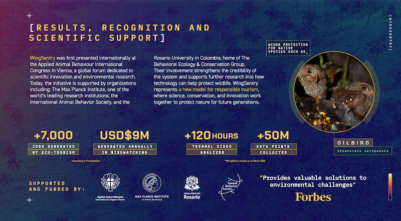
According to PROColombia, the country’s national agency for tourism, with nearly 20% of the world’s bird species, Colombia ranks first in global bird diversity. Birdwatching alone generates more than 7,000 jobs and over $9 million annually.
“The environmental impact of AI has been questioned, so we gave AI a positive purpose: helping tourism coexist with the very nature people travel to see,” stated Juan Diego Pineda, biologist and lead researcher in the project. “Protecting these species is essential.”
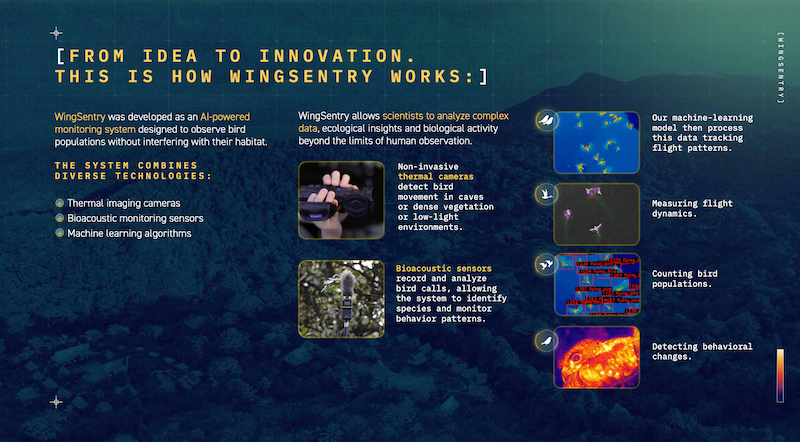
WingSentry combines thermal imaging technology with bioacoustic sensors to observe wildlife with zero habitat disturbance. The value of the system lies not only in the data it collects, but in how that data is applied. WingSentry translates complex ecological information into practical guidance for tourism operators, helping them design bio-corridors that avoid sensitive nesting areas and reduce human impact.
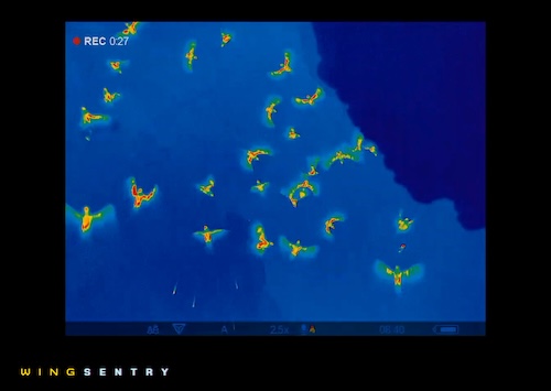
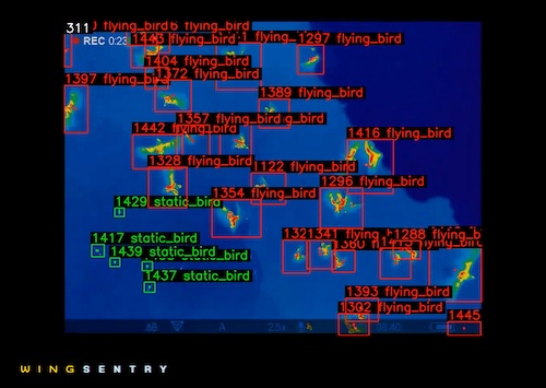
The system was validated through an extensive field-testing program in Colombia. During the pilot phase, approximately 120 hours of synchronised audio and thermal video data were captured. Preliminary site reconnaissance was conducted in 2024 via four distinct expeditions to Cuevas del Peñón (Santander), each consisting of one-week sessions. Subsequently, the final exploratory data acquisition phase took place in 2025 at both La Danta (Antioquia) and Cuevas del Peñón. This final stage was two intensive sessions, each six weeks long. All data collection was integrated with an ongoing population estimation study of the Oilbird (Steatornis caripensis), one of the Andes native bird species. The data gathering results of the field sessions analysed several hours of thermal and acoustic recordings, and the Al system analysed over 50 million data points, as of March 2026.
The software and machine-learning system was developed using Python, RStudio, and Jupyter Notebook, and used public open source platform, BehaveAI. The AI system analyses millions of data points to identify species, maps trajectories, count populations and detects behavioural patterns, key information to guide tourism operators.
The project was first presented locally at the III Colombian Congress of Speleology and at the VIII Colombian Ornithology Congress; and internationally at the Animal Behaviour International Congress in Vienna. Since then, WingSentry secured support from the Animal Behaviour Society and the Max Planck Institute, one of the most important scientific entities worldwide. And the impact reaches everyone: Strengthened tourism as a sustainable alternative to illicit crop economies, bird species receive stronger protection and travelers enjoyed Colombia’s natural beauty more responsibly.